In 2026, the Brandywine Conservancy assisted East Nottingham Township with the adoption of an Official Map and Ordinance pursuant to Article IV of the Pennsylvania Municipalities Planning Code. An Official Map serves as a planning tool that enables municipalities to guide future growth and identify areas intended for public benefit. Specifically, it designates the locations of existing and proposed streets, waterways, parks, open space, and other public lands or facilities.
East Nottingham Township’s Official Map identifies areas for potential open space, agricultural easements, and greenway corridors to preserve the Township’s rural character and agricultural heritage. By establishing a long-term vision for public improvements and infrastructure, this Official Map will help preserve areas needed for future rights-of-way, recreational amenities, and other community assets.
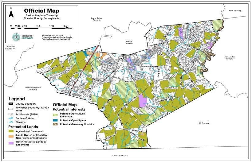
How Does it Work?
An Official Map is distinct from a municipal zoning map and does not constitute a taking of private property. Rather, it is a planning mechanism that allows a municipality to express an interest in land or facilities that may be needed for future public purposes while providing an opportunity for discussion and negotiation between the municipality and property owners.
Following adoption, the Official Map is only implemented when a property identified on the map is proposed for sale or when a landowner submits a Subdivision and Land Development Ordinance (SALDO) application. In these instances, the municipality is granted a one-year period to evaluate the proposed action and negotiate with the property owner regarding potential acquisition or preservation options. Such discussions may include the dedication of a trail easement, acquisition of land for park and recreational purposes, or the establishment of conservation easements to ensure the long-term protection of important natural or community resources.
East Nottingham Township's Official Map was funded by Chester County's Vision Partnership Mini Grant Program, with Brandywine Conservancy served as the consultant. If your municipality would like to learn more about the Official Map process, please reach out to staff in our Municipal Assistance Program at [email protected].